Feel the spirit of Australia (c) 1999 - 2005 by Foxi

HomeRentals & ToursFlights & MoreService & Forums - NewsboardsShopping & MoreAustralien InfosSchatzsuche - FossickingHilfe FAQ's - Fragen & Antworten
Newsletter an oder abmelden
Das Quiz
Frage oder Angebot - Buchung
Seite weiter empfehlen
Schnell Suche ...
  
Australien Bücher

Hier finden Sie Bücher über Tierwelt, Nationalparks, Landkarten,CD's , DVD's ,Video's und vieles mehr.

Australien erleben
Australien Reiseberichte und Australien Infos ...
Alle Rentals
Hier finden Sie alle Rentals im Überblick.
Australien Fotos
Erleben Sie Down Under mit unserer Foto Show. Über 800 Fotos rund um Australien ...
Reiseroute Planung
Ihre persönliche Reiseroute können Sie hier anfordern.Sie geben uns Ihre Eckdaten und wir erarbeiten daraus Ihre persönliche Reiseroute. Lesen Sie mehr darüber ...
Ferienwohnungen
Sie suchen Hotels oder Ferienwohnungen.  Dann sind Sie hier richtig 
 
Australien Info Forum
Ob Auswandern oder Reisepartner Suche im Australien Info Forum finden Sie Antworten auf Ihre Fragen oder können selber Fragen stellen.
Schatzsuche in Down Under / Fossicking
Finden Sie Ihre eigenen Edelsteine in Australien mit der Fossicking CD. Als Download oder als CD erhältlich.
Reiseroute & Camping
Ihre persönliche Reiseroute können Sie hier anfordern.  ....

Outback Info (Private Seiten) © seit 1999

Bundjalung National Park

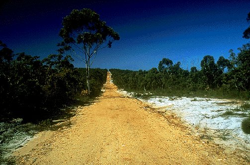
This park has a total area of 17,679 hectares. It is located on the North Coast north of lluka near Yamba. Four wheel drive access along the beach between Woody Head and Black Rocks is permitted.

This park protects unusual coastal heath. It is serviced by a large camping area at Woody Head for which you must book. This is an ideal place for fishermen and surfers and the four wheel drive access along the beach ensures that you can escape the holiday crowds.

For more information contact NPWS on 066 466134

Picture: Bundjalung National Park (Courtesy Random House
 

Guy Fawkes River

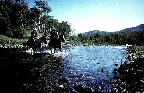
This park has a total area of 35,630 hectares. It is located in remote country 60 km west of Dorrigo off the Chaelundi Forest road. There is limited four wheel drive access as all the surrounding access trails are gravel and would be very slippery in wet weather.

This park stretches along the banks of the Guy Fawkes River which passes through extremely remote and rugged land. There is a campsite at Chaelundi rest area which also has numerous long walking trails radiating from it. This area would be best suited to the experienced bushwalker. The surrounding state forest country contains some four wheel drive tracks, the Liberation trail being the best of these. Be prepared for fallen timber and deep river crossings.

For more information contact NPWS on 066 572309

Picture: (Courtesy NSW National Parks and Wildlife Service.)
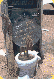


Eine Seite zurück
Links & Infos
Tipp:Hier können  Sie Ihren Reisebericht veröffentlichen
Forum
Auktionen
New Links
FreeM@il
Ihre Route
Quiz
OZ-Postkarten
Australien Shop
Australien Camper
Australien Camping
Neuseeland Camper
AU / NZ Hotels
Affiliate 4 your Web
Impressum
Datenschutz
Outback Infos
Home
Tierwelt
Frösche
Kookaburra
Schlangen
Spinnen
Lizards
Kangaroo
Krocodiles
Wildlife Melbourne
Dingo
Vögel
Kakadus
TAZ
Koala
Unterwasserwelt
Wombat
Allgemein & Kultur
Aboriginal Info
Aboriginal Frauen
Traumzeit
Bumerang
Klimadaten
Entfernung
Entdeckungsgeschichte
Australien Übersicht
Feiertage
Zentralaustralien
Wirtschaftsprofil
Zeitzonen
Slang
Stammtische
Kochrezepte
Studieren
Diverses
Game
Fossicking
Fossicking CD
Gold suchen
Fossicking Links
Edelsteine
Metall Detektoren
Reiseberichte
Durchs Outback
Schatzsuche
Outback Bericht
Malcolm Douglas
Rotes Zentrum
Sydney - Darwin
Ayers Rock - Olgas
Mit dem Bike
Sydney - Cairns
Nationalparks
New South Wales
South Australia
Queensland
Northern Territory
Western Australia
Avon Valley
Boorabin
Brockman
Cape Arid
Le Grand
Cape Range
D'Entrecasteaux
Drysdale
Fitzgerald
Gloucester
Geikie Gorge
John Forrest
Kalbarri
Karijini
Kennedy Range
Leeuwin-Naturaliste
Lesueur
Millstream-Chichest
Mirima
Mitchell River
Mount Frankland
Mount Augustus
Nambung
Neerabup
Rudall River
Shannon
Stirling Range
Stokes
Torndirrup
Tuart Forest
Two People Bay
Walpole-Nornalup
Walyunga
Waychinicup
William Bay
Windjana Gorge
Wolfe Creek Crater
Yalgorup
Yanchep
Australien Tracks
Birdsville Track
Desert Tracks
Oodnadatta Track
Australien Reiseinfo
Der Aussie
Australien A-Z
Entfernung
Webcam
Zugverbindung
Backpacker A-Z
Hotel Infos
Stadtpläne
Australienkarten
Downloads
Edelsteine
 
Schatzsuche in Down Under / Fossicking
Finden Sie Ihre eigenen Edelsteine in Australien mit der Fossicking CD.
The Aussie QUIZSeite weiter empfehlen ...Aktuelle NEWS ...Rental SchnellsucheSchnell Suche ...Forum & NewsboardsBookmark www.outback-info.de
Outback-Info.de © seit 1999.  Design by Foxi. 800X600 - 1024X768. Optimiert für IE ab 5.X und Netscape ab 7.X >>Impressum<<  >>Werbung<<
Australien-Kanal.de © seit 1999, Fossicking.de © seit 1999