Feel the spirit of Australia (c) 1999 - 2005 by Foxi

HomeRentals & ToursFlights & MoreService & Forums - NewsboardsShopping & MoreAustralien InfosSchatzsuche - FossickingHilfe FAQ's - Fragen & Antworten
Newsletter an oder abmelden
Das Quiz
Frage oder Angebot - Buchung
Seite weiter empfehlen
Schnell Suche ...
  
Australien Bücher

Hier finden Sie Bücher über Tierwelt, Nationalparks, Landkarten,CD's , DVD's ,Video's und vieles mehr.

Australien erleben
Australien Reiseberichte und Australien Infos ...
Alle Rentals
Hier finden Sie alle Rentals im Überblick.
Australien Fotos
Erleben Sie Down Under mit unserer Foto Show. Über 800 Fotos rund um Australien ...
Reiseroute Planung
Ihre persönliche Reiseroute können Sie hier anfordern.Sie geben uns Ihre Eckdaten und wir erarbeiten daraus Ihre persönliche Reiseroute. Lesen Sie mehr darüber ...
Ferienwohnungen
Sie suchen Hotels oder Ferienwohnungen.  Dann sind Sie hier richtig 
 
Australien Info Forum
Ob Auswandern oder Reisepartner Suche im Australien Info Forum finden Sie Antworten auf Ihre Fragen oder können selber Fragen stellen.
Schatzsuche in Down Under / Fossicking
Finden Sie Ihre eigenen Edelsteine in Australien mit der Fossicking CD. Als Download oder als CD erhältlich.
Reiseroute & Camping
Ihre persönliche Reiseroute können Sie hier anfordern.  ....

Outback Info (Private Seiten) © seit 1999

Kings Canyon

To enter the remainder of the park you must back track to Hermannsburg and take the track opposite the turnoff to the community. This 10 km track takes you into Ellery Creek and 20 km along the river bed through the red wall gorges to Boggy Hole. This track is very sandy in places and it is not advisable to tow trailers. In years gone by, there used to be direct access from Palm Valley through the Glen of Palms along the Finke River to Boggy Hole. During the 1988 flood, a huge mound of soft sand was deposited in the gorge, making it very difficult to negotiate by vehicle. Many travellers needed assistance, and so this part of the gorge was closed off as the Rangers did not have the time to help the stranded off-roaders.

Boggy Hole is a pleasant camping spot with no facilities. There are some shady campsites and swimming and canoeing may be enjoyed. On the east bank of the river is the ruin of the old police station. From this point, an old seismic track takes you due east 62 km to the Stuart Highway. The trek is scenic but very slow and will take you up to 6 hours. You cross over the Drive south from Boggy Hole 68 km to the Ernest Giles Highway, in and out of the Finke River past Cocky's Camp, Running Waters Yard and the turn off to Illamurta Spring. At the highway, turn left to the Stuart Highway or the other way to Kings Canyon.

Picture: Kings Canyon (Courtesy Random House)

Uluru-Kata Tjuta

Ernest Giles and W.E. Gosse came in 1872 and 1873, mapping the Aboriginal landscape in the explorer tradition. Prospectors, dingo hunters and missionaries followed. Large sheep and cattle stations were established over Aboriginal land. Often the meeting of the two cultures was unfriendly.

Grazing depleted bush food resources. During severe droughts in the 1930s and 1950s, Aboriginal people were drawn into missions, cattle stations and government settlements by the prospect of a reliable food supply and by curiosity.

Despite attempts to settle and to school Aboriginal people in the ways of the outside world, Anangu, the original owners of the Uluru-Kata Tjuta National Park, continued their traditional ways.

They travelled traditional lands visiting kin, returning to bush foods, arranging and attending ceremonies and teaching young people the skills and beliefs that had always been essential to their survival. Anangu maintained their ties with traditional lands.

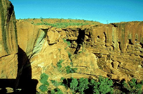
Geologically, Uluru and Kata Tjuta are the relics of an immense bed of sedimentary rock now almost entirely covered by debris from erosion and by wind-blown sand. The 36 individual domes of Kata Tjuta once may have been a single dome many times the size of Uluru. The features of the inselbergs and the surrounding plain are the product of millions of years of weathering and erosion.

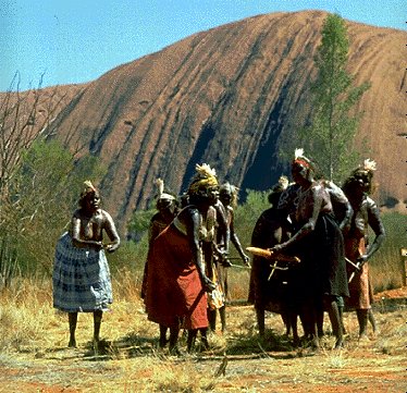
Aboriginal people know that Uluru and Kata Tjuta were created and shaped into their unique forms during the Tjukurpa or creation period. Individual features represent the visual imprints and physical proof of the activities of ancestral beings of the Tjukurpa.

To have survived in a land that others call harsh, Aboriginal people needed to know their land well. Today, they are passing on their knowledge and their skill in 'reading' the land so that others might understand and appreciate it as they do.

So far 150 different kinds of birds, 22 mammals, many reptiles and frogs, and nearly 400 plant species have been recorded in the Park area. Visitors are likely to see only a few of these. However, those who take time to walk the tracks will be rewarded by seeing fascinating dryland plants and animals which cope with this environment.

In 1987 the Park was inscribed to the United Nations World Heritage List. It is also one of twelve Australian Biosphere Reserves.

Picture: (Courtesy DFAT)


Eine Seite zurück
Links & Infos
Tipp:Hier können  Sie Ihren Reisebericht veröffentlichen
Forum
Auktionen
New Links
FreeM@il
Ihre Route
Quiz
OZ-Postkarten
Australien Shop
Australien Camper
Australien Camping
Neuseeland Camper
AU / NZ Hotels
Affiliate 4 your Web
Impressum
Datenschutz
Outback Infos
Home
Tierwelt
Frösche
Kookaburra
Schlangen
Spinnen
Lizards
Kangaroo
Krocodiles
Wildlife Melbourne
Dingo
Vögel
Kakadus
TAZ
Koala
Unterwasserwelt
Wombat
Allgemein & Kultur
Aboriginal Info
Aboriginal Frauen
Traumzeit
Bumerang
Klimadaten
Entfernung
Entdeckungsgeschichte
Australien Übersicht
Feiertage
Zentralaustralien
Wirtschaftsprofil
Zeitzonen
Slang
Stammtische
Kochrezepte
Studieren
Diverses
Game
Fossicking
Fossicking CD
Gold suchen
Fossicking Links
Edelsteine
Metall Detektoren
Reiseberichte
Durchs Outback
Schatzsuche
Outback Bericht
Malcolm Douglas
Rotes Zentrum
Sydney - Darwin
Ayers Rock - Olgas
Mit dem Bike
Sydney - Cairns
Nationalparks
New South Wales
South Australia
Queensland
Northern Territory
Western Australia
Avon Valley
Boorabin
Brockman
Cape Arid
Le Grand
Cape Range
D'Entrecasteaux
Drysdale
Fitzgerald
Gloucester
Geikie Gorge
John Forrest
Kalbarri
Karijini
Kennedy Range
Leeuwin-Naturaliste
Lesueur
Millstream-Chichest
Mirima
Mitchell River
Mount Frankland
Mount Augustus
Nambung
Neerabup
Rudall River
Shannon
Stirling Range
Stokes
Torndirrup
Tuart Forest
Two People Bay
Walpole-Nornalup
Walyunga
Waychinicup
William Bay
Windjana Gorge
Wolfe Creek Crater
Yalgorup
Yanchep
Australien Tracks
Birdsville Track
Desert Tracks
Oodnadatta Track
Australien Reiseinfo
Der Aussie
Australien A-Z
Entfernung
Webcam
Zugverbindung
Backpacker A-Z
Hotel Infos
Stadtpläne
Australienkarten
Downloads
Edelsteine
 
Schatzsuche in Down Under / Fossicking
Finden Sie Ihre eigenen Edelsteine in Australien mit der Fossicking CD.
The Aussie QUIZSeite weiter empfehlen ...Aktuelle NEWS ...Rental SchnellsucheSchnell Suche ...Forum & NewsboardsBookmark www.outback-info.de
Outback-Info.de © seit 1999.  Design by Foxi. 800X600 - 1024X768. Optimiert für IE ab 5.X und Netscape ab 7.X >>Impressum<<  >>Werbung<<
Australien-Kanal.de © seit 1999, Fossicking.de © seit 1999